


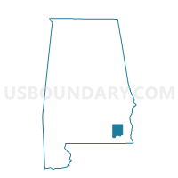
Level Plains, Dale County, Alabama
About
Outline

Summary
| Unique Area Identifier | 521641 |
| Name | Level Plains |
| County | Dale County |
| State | Alabama |
| Area (square miles) | 17.02 |
| Land Area (square miles) | 17.02 |
| Water Area (square miles) | 0.00 |
| % of Land Area | 100.00 |
| % of Water Area | 0.00 |
| Latitude of the Internal Point | 31.30659270 |
| Longtitude of the Internal Point | -85.76709970 |
Maps


Graphs
Select a template below for downloading or customizing gragh for Level Plains, Dale County, Alabama


Neighbors
Neighoring Voting District (by Name) Neighboring Voting District on the Map
- Clayhatchee, Dale County, AL
- Cool Springs Volunteer Fire Dept., Coffee County, AL
- Daleville, Dale County, AL
- Fort Rucker, Dale County, AL
- Heritage Church, Coffee County, AL
- John's Chapel Church, Coffee County, AL
Top 10 Neighboring County Subdivision (by Population) Neighboring County Subdivision on the Map
- Enterprise CCD, Coffee County, AL (35,493)
- Daleville CCD, Dale County, AL (11,976)
- Fort Rucker CCD, Dale County, AL (4,642)
Top 10 Neighboring Place (by Population) Neighboring Place on the Map
- Enterprise city, AL (26,562)
- Daleville city, AL (5,295)
- Fort Rucker CDP, AL (4,636)
- Level Plains town, AL (2,085)
Top 10 Neighboring Unified School District (by Population) Neighboring Unified School District on the Map
- Enterprise City School District, AL (26,562)
- Coffee County School District, AL (18,627)
- Daleville City School District, AL (11,560)
- Fort Rucker School District, AL (4,647)
Top 10 Neighboring State Legislative District Lower Chamber (by Population) Neighboring State Legislative District Lower Chamber on the Map
- State House District 91, AL (49,948)
- State House District 93, AL (46,741)
- State House District 89, AL (44,249)
Top 10 Neighboring State Legislative District Upper Chamber (by Population) Neighboring State Legislative District Upper Chamber on the Map
Top 10 Neighboring 111th Congressional District (by Population) Neighboring 111th Congressional District on the Map
Top 10 Neighboring Census Tract (by Population) Neighboring Census Tract on the Map
- Census Tract 112.02, Coffee County, AL (8,530)
- Census Tract 112.01, Coffee County, AL (8,036)
- Census Tract 211.01, Dale County, AL (4,893)
- Census Tract 200, Dale County, AL (4,642)
- Census Tract 211.02, Dale County, AL (4,387)
- Census Tract 113, Coffee County, AL (4,160)
- Census Tract 108, Coffee County, AL (2,840)
- Census Tract 212, Dale County, AL (2,696)